Snowpack – vital for our way of life and for healthy watersheds
2020 Trends | Watershed Health
The snowpack that accumulates each winter in Boulder County has a huge influence on the quality and quantity of water that we’ll have to use over the course of the summer and fall, and how full our streams and rivers will be to support aquatic ecosystems.
Snowpack is defined in the dictionary as “a seasonal accumulation of slow-melting packed snow.” To those of us who live and work in the semi-arid landscapes of Boulder County, snowpack is essential for providing the water we need to drink, swim, water our crops and lawn, and use for industrial purposes, as well as supporting our diverse and productive wetland, stream, and riparian ecosystems.
Boulder County contains the St. Vrain and Boulder Creek watersheds, and sits within the larger South Platte River Basin, which covers most of central and eastern Colorado, from the Continental Divide west of Boulder to the Nebraska border. The Natural Resources Conservation Service (NRCS), a federal agency with offices in each county, gathers data on snowpack to predict spring runoff and summer streamflow amounts. These are typically reported as a percentage compared to the median snowpack, derived from the data from all years in the data set.
In Boulder County, the NRCS uses several SNOTEL (“SNOw TELemetry Network”) sites, including one near Niwot Ridge in the mountains of western Boulder County, to estimate snowpack for the St. Vrain Creek and Boulder Creek watersheds. The figures below show that the accumulation of snowpack in these two adjacent watersheds is fairly similar, except for two months of the year.
In particular, for the St. Vrain Creek watershed, January is far more variable than other months across the 30-year period and in 2007, the January snowpack exceeded the median snowpack by about 200%. In addition to the five months of the year tracked for the St. Vrain Creek watershed, the Boulder Creek watershed contains data for the month of June, which is the most variable month of the data set (Figure 1). Since 2015, snowpack has generally been higher than the median for the 30-year period for both watersheds.
explore the data
30 years of snowpack data for the St. Vrain and Boulder Creek watersheds
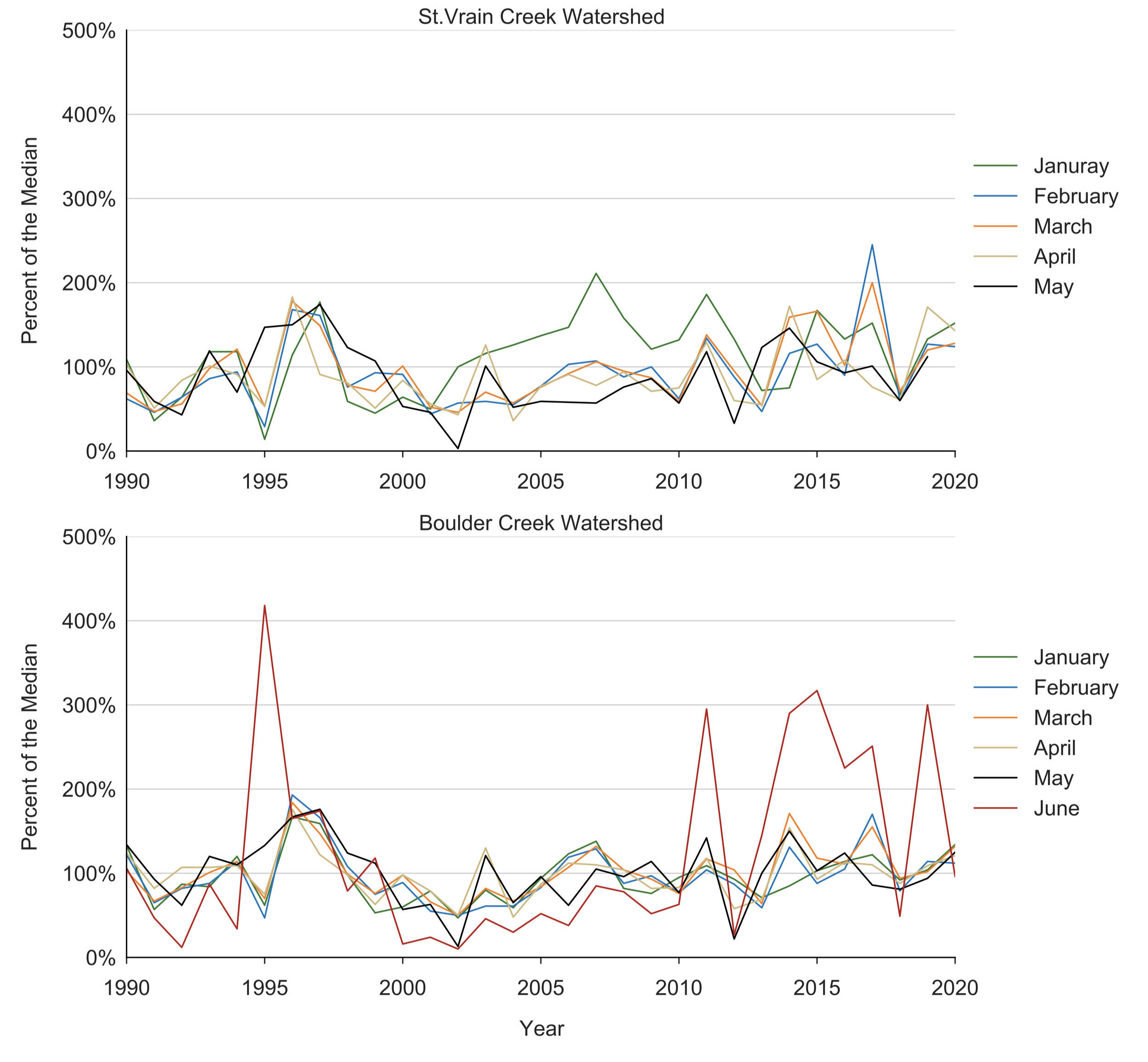
Figure 1. Snowpack data (percent of the median) for the St. Vrain (upper panel) and Boulder Creek (lower panel) watersheds, from 1990 to 2020. For each year of the data set, the value of snowpack depth plotted for that month represents the departure from the median value for that month over the entire data set. The USDA Natural Resource Conservation Service uses several SNOTEL sites to calculate the St. Vrain Creek and Boulder Creek watershed snowpack. The seasonal patterns of snowpack in these two adjacent watersheds are remarkably similar. However, only the Boulder Creek data set contains snowpack data for the month of June. Source: USDA NRCS Colorado data from several SNOTEL sites.
about the data
SNOTEL’s snowpack data are associated with watersheds (St. Vrain Creek and Boulder Creek, in this case) because a large majority of the water that enters those watersheds comes from snowpack. A large portion of runoff comes from snowpack too, which can be good and bad. The good kind of runoff is the kind that fills our reservoirs, keeps creeks and rivers flowing, and provides enough water for people upstream and downstream.
The bad kind of runoff is when snow melts and carries potential pollutants, such as nutrients from lawn fertilizers, pesticides from lawn and garden chemicals, petroleum by-products from vehicles and roadways, and bacteria from human and animal waste into our surface water and groundwater.
The types of land cover in a watershed strongly influence the quality and amount of runoff.
As the human population in Boulder County has increased over the past several decades, the area of impervious surfaces has also increased, which shifts the amount of “bad” runoff and may influence watershed health. For more information, see the companion watershed health story in this report focused on urban population growth.
Watch this video from CU boulder to learn more about snowpack and watershed health in Boulder County:
recommendations
Get involved in measuring snowpack!
There is a vibrant community-science project aimed at local measurements of snowpack in mountain regions across North America, called Community Snow Observations.
Join the activities of the Boulder-based organization Protect Our Winters, which is focused on motivating the outdoor community to implement actions to minimize the negative impacts of climate change.
Manage your residential landscape to reduce “bad” runoff, by minimizing your use of lawn and garden pesticides and synthetic fertilizers, and by reducing the area of impervious surfaces, such as driveways and walkways.
When you’re installing a new patio, path, or driveway, try using surfaces that permit drainage, such as permeable or porous pavers.